Agricultural spray drone services

What can a spray drone do?
Spray drones are currently permitted to apply fertiliser and biostimulants as well as most unregulated product. Importantly, spray drones can apply seeding for both crop and cover-crop. By using both satellite and RTK corrections, drones are precise in their application so Farmers can be sure that resources are applied only where needed.
Additionally spray drones can be used to apply green house shading agents, meaning scaffolding and ladders are no longer a safety consideration.
Spray drones can also access areas that are normally problematic, meaning that no areas are missed.
Multispectral crop surveys will help pointpoint where the issues are, with a prescription map generated to be uploaded into a spray drone or other smart farm machinery. Aside from the environmental benefits, Farmers can make significant savings on time and resource whilst protecting the end of season yield.
If you'd like to find out how we can help, call us on 02382 146615 or send us a message!
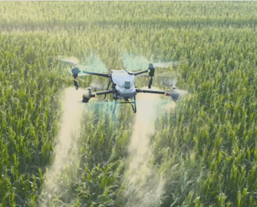
Spray Drones for agriculture
Using spray drones to apply fertilsers, biostimulants and seeding is fast becoming a standard practice of farming. Drones can cover up to 200 acres per day and are perfect for when the ground is wet and at risk of damage from compaction by heavy machinery.
Call us on 02382 146615
Email us at hello@lowaltitude.co.uk
Low Altitude Ltd
Hampshire Wiltshire Dorset Sussex
CAA Operator ID: GBR-OP-9VK7SHBYWQVW
Chief Pilot Flyer ID: GBR-RP-RMZFRWLH8QD7
CAA Operational Authorisation held
Copyright © 2026 Low Altitude - All Rights Reserved.